Dams in Central Western Ghats Affecting Catchment of Perennial Rivers

Dams in Central Western Ghats Affecting Catchment of Perennial Rivers

  • Research Stash
  • News
  • 2.7K

A recent study has found that unplanned developmental activities and land use are reducing the evergreen forest cover and perennial streams in the central region of the Western Ghats in India.

Indian researchers have mapped how large-scale activities have eroded the ecosystem in the central Western Ghats, a biodiversity hotspot known for its rich ecology, natural forest systems, and perennial rivers.

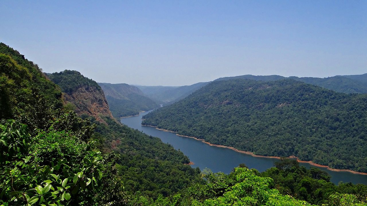
The study focussed on Kali river that originates in Uttara Kannada district in Karnataka and joins the Arabian Sea. The river is as old as the Western Ghats, has six major dams, 325 species of flora, and 190 species of fauna.

Using remote sensing data, the researchers found that between the years 1973 and 2016, the forest cover has reduced from 85% to 55%. In addition, land use pattern in the region has changed during 1980–2000 period due to developmental projects such as dams built on the river Kali, Kaiga nuclear plant and Dandeli paper mill. The paper mill has led to the large-scale conversion of forests to crops.

Evergreen forests have shrunk from 62% to 38.5% during this period, and large water reservoirs have been constructed at the expense of forest cover, the study notes.

The eco-hydrological footprint is a measure of how the ecology of a region responds to changes in the water cycle and water usage. This can be measured by assessing the ratio of available water and water lost due to usage and evaporation. Around 2309 million cubic meters of water are required for the demands of society and livestock in the region, while around 4700 million cubic meters is required to maintain ecosystems and aquatic life.

Analysis showed that although Kali river has sufficient water supply and perennial streams in the Ghats and coastal area, regions that lie in plain lands with a higher degree of agriculture and cultivation have an intermittent and seasonal flow that has led to water scarcity for 4 to 9 months in a year.

Perennial streams were found in regions that have greater than 70% of forest cover, showing the link between ecology and hydrology with land use. “Forests with native species of vegetation play a pivotal role in enhancing the water retention capability of the catchment”, T V Ramachandra, a scientist at the Indian Institute of Science and a member of research team, told India Science Wire.

“Villagers in the vicinity of native forests earn Rs 1.54 lakh per acre per year compared to Rs 32000 in villages with stream catchments experiencing deforestation. This confirms a vital role of native forests in sustaining water and people’s livelihood,” he added.

The study said that management practices adopted by engineers were contributing to the erosion of water retention capability in the river catchment with severe water scarcity. The government agencies should establish better management and conservation strategies to maintain forest cover for food and water security.

The research team included T V Ramachandra and S Bharath (Indian Institute of Science, Bengaluru); S Vinay and A. Shashishankar (Visvesvaraya Technological University, Belagavi, India). The study was published in Yale Journal of Biology and Medicine. (India Science Wire)

By Dr. P Surat

Journal Article

Eco-Hydrological Footprint of a River Basin in Western Ghats

If you liked this article, then please subscribe to our YouTube Channel for the latest Science & Tech news. You can also find us on Twitter & Facebook.

Rate

Using remote sensing data, the researchers found that between the years 1973 and 2016, the forest cover has reduced from 85% to 55%. In addition, land use pattern in the region has changed during 1980–2000 period due to developmental projects such as dams built on the river Kali, Kaiga nuclear plant and Dandeli paper mill. The paper mill has led to the large-scale conversion of forests to crops.

Evergreen forests have shrunk from 62% to 38.5% during this period, and large water reservoirs have been constructed at the expense of forest cover, the study notes.

The eco-hydrological footprint is a measure of how the ecology of a region responds to changes in the water cycle and water usage. This can be measured by assessing the ratio of available water and water lost due to usage and evaporation. Around 2309 million cubic meters of water are required for the demands of society and livestock in the region, while around 4700 million cubic meters is required to maintain ecosystems and aquatic life.

Analysis showed that although Kali river has sufficient water supply and perennial streams in the Ghats and coastal area, regions that lie in plain lands with a higher degree of agriculture and cultivation have an intermittent and seasonal flow that has led to water scarcity for 4 to 9 months in a year.

Perennial streams were found in regions that have greater than 70% of forest cover, showing the link between ecology and hydrology with land use. “Forests with native species of vegetation play a pivotal role in enhancing the water retention capability of the catchment”, T V Ramachandra, a scientist at the Indian Institute of Science and a member of research team, told India Science Wire.

“Villagers in the vicinity of native forests earn Rs 1.54 lakh per acre per year compared to Rs 32000 in villages with stream catchments experiencing deforestation. This confirms a vital role of native forests in sustaining water and people’s livelihood,” he added.

The study said that management practices adopted by engineers were contributing to the erosion of water retention capability in the river catchment with severe water scarcity. The government agencies should establish better management and conservation strategies to maintain forest cover for food and water security.

The research team included T V Ramachandra and S Bharath (Indian Institute of Science, Bengaluru); S Vinay and A. Shashishankar (Visvesvaraya Technological University, Belagavi, India). The study was published in Yale Journal of Biology and Medicine. (India Science Wire)

By Dr. P Surat

Journal Article

Eco-Hydrological Footprint of a River Basin in Western Ghats

If you liked this article, then please subscribe to our YouTube Channel for the latest Science & Tech news. You can also find us on Twitter & Facebook.

" }

Genetic barcodes are used to quantify crucial populations in a coral reef ecosystem

Almost all the wildly varied, colorful fish that populate coral reefs start life as tiny, colorless, tadpole-like larvae. Telling one from the other is nearly impossible – even for experts – and this presents a difficult challenge to those who study the ecology of the reefs.

  • News
  • 2.3K
Read more

Scientists Complete Genetic Sequencing of Chickpea

After three years of rigorous research, a team of scientists from International Crops Research Institute for the Semi-Arid Tropics here and 21 research institutions across the world has successfully completed the sequencing of 429 chickpea lines from 45 countries

  • News
  • 1.9K
Read more
A Measure of Smell

A Measure of Smell

In a new study on the sense of smell, Weizmann Institute of Science researchers has managed to strip much of the mystery from even complex blends of odorants, not by uncovering their secret ingredients, but by recording and mapping how they are perceived.

  • News
  • 1.6K
Read more

Internet is huge! Help us find great content

Newsletter

Never miss a thing! Sign up for our newsletter to stay updated.

About

Research Stash is a curated collection of tools and News for S.T.E.M researchers

Have any questions or want to partner with us? Reach us at hello@researchstash.com

Navigation

Submit